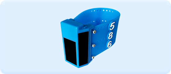
| SIZE | |
| Length | 36mm |
| Width | 25mm |
| Height | 54mm |
| Diameter | 14-26mm |
| Weight | 25~46g |
| Antenna | Internal |
| Material | Japan OTS |
| Configuration | Neck Ring |
| SPECIFICATIONS | |
| Battery | Rechargeable battery |
| Charging Method | Solar Charge |
| Working Without Solar Charging | More than 30 days |
| Time pattern | Greenwich Mean Time (GMT) |
| Operating Temperature Range | -40°C& to 65°C |
| Positioning Accurancy | ±2.5m |
| Storage | 1400~50000 |
| Signal transmission mode | ≤120s |
| Humidity Range | 5%—95% |
| Waterproof Level | IP68 |
| Location information | Time, date, latitude and longitude, 2D/3D value, PDOP value |
| SENSORS | ||||
| Temperature | Speed | Altitude | Activity | Battery Voltage |
| APPLICATION | |
| Areas | Global |
| Positioning Mode | BDS、GPS |
| Transmission Mode | GSM |
| International roaming | |
| WARRANTY |
| 1 year limited warranty |
| OPERATIONAL LIFE |
| More than 2 years |
| ACCESSORIES:Included |
| REMOTE |
| Remotely control switch on /off, change the positioning interval and transmission cycle |
| SOFTWARE |
| The device will transmite the location data to the server automatically ,don't need to recapture animals to download data,and you can view location data through Baidu or Google maps.All location & sensor data can be exported into Excel & CSV data file format.Besides it can also be exported into the KML formats that can be viewed in Google Earth™ |